Categories
Bucknell/Local Interest Events/Calendar General GIS Slideshow

Additional GIS faculty workshop added – register now for funded seats

Three GIS workshops for faculty will be offered during Summer 2011.

Introductory GIS workshop (3 days) – NEW
Wednesday, June 1st through Friday, June 3rd from 9am-2pm
(lunch provided)

Introductory GIS workshop (4 days)
Monday, August 8th through Thursday, August 11th from 9am-1pm
(lunch provided)

Advanced GIS workshop (2 days)
Monday, August 15th through Tuesday, August 16th
(lunch provided)

These grant supported workshops ($400 for each participant) will enable 12 faculty to engage in a hands-on GIS experience designed to be broadly useful to faculty, regardless of their specific disciplines and areas of research. To make the workshop experience more meaningful and relevant, both the introductory and advanced workshops will feature local data and topics of interest

If you are interested in participating, please click the link below to complete the GIS workshop interest form. Please note – there is a limit of 12 funded seats for the Summer 2011 GIS Workshops. Additional Mellon funded GIS workshop opportunities will be announced prior to summer 2012 and 2013 sessions.

Click here to access GIS workshop interest form.

Categories
Environment General GIS GIS in Environmental Studies GIS in Geography GIS in Sociology Map Apps Slideshow Videos

Go Philly! GIS helps improve access to healthy food in the city

Yesterday’s NY Times had an opinion piece praising Philadelphia’s efforts in recent years to improve access to healthy food for its most disadvantaged neighborhoods and citizens.  In ‘Go Philly!’, Mark Bittman describes the collaborative efforts of Philadelphia municipal government, the Commonwealth of PA and a whole host of local non-profits (including my former employer, the newly renamed  Greater Philadelphia Urban Affairs Coalition) in developing programs to bring supermarkets and healthy food options to under-served neighborhoods.

What he doesn’t describe is the critical role that GIS has played in bringing these programs to life.  See below for some background information and resources related to using GIS for improving access to healthy food.

1. Watch this short video (Ch. 3 of Episode 2 from Penn State’s Geospatial Revolution video series) to learn more about the role of GIS in Philadelphia’s ‘healthy food’ success story.

httpv://www.youtube.com/watch?v=RYzHcPHRhWQ

2. Read reports from the Food Trust and The Reinvestment Fund (TRF) describing their work in Philadelphia and other communities. Both organizations are Philadelphia-based non-profits that have been at the center of Philadelphia’s efforts to improve access to healthy food.

“The Grocery Gap: Who Has Access to Healthy Food and Why It Matters” – click here

Food Trust/TRF Report on the Fresh Food Financing Initiatives projects – click here

TRF’s resource page on food access – click here

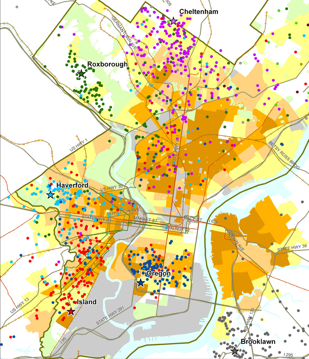
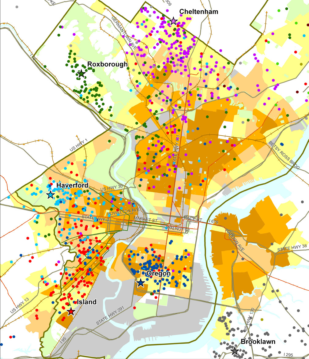
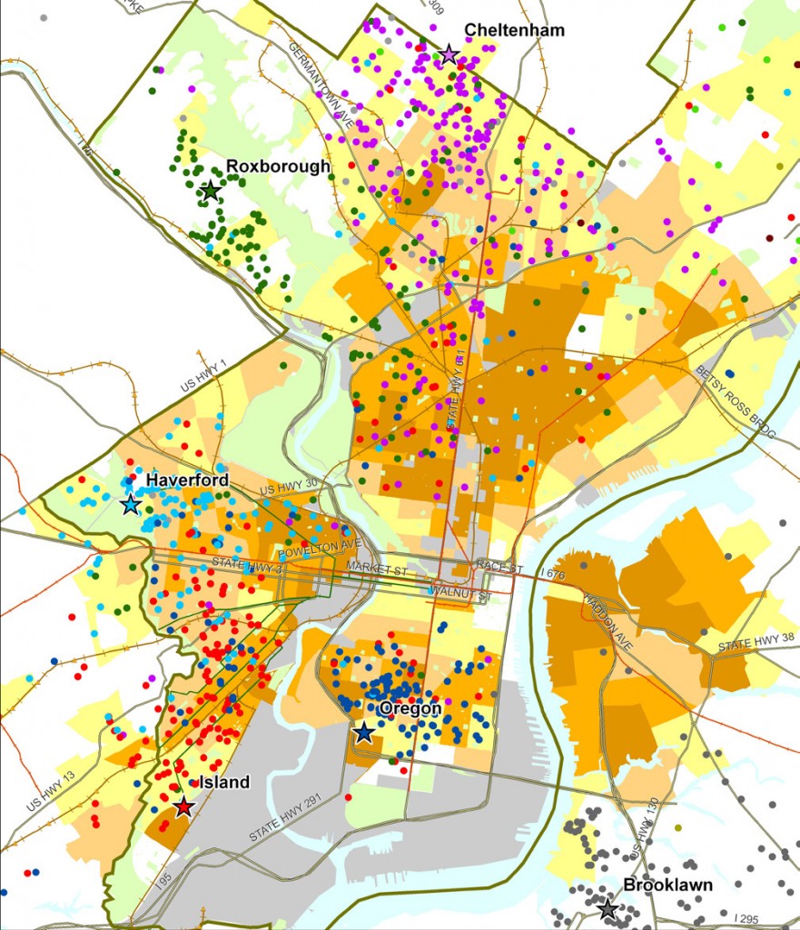
Sample map from Food Trust/TRF report on the Fresh Food Financing Initiative:

“Map 1: Residence of ShopRite Employees by Poverty Rate of Census Tract.  Each star on the map represents a Brown’s ShopRite store, with the location of the store’s employees illustrated by correspondingly colored dots.”
 

3. Watch a video created by TRF in collaboration with the Brookings Foundation to describe their use of GIS and findings in their  “Getting to Market” report on healthy foods initiatives across the U.S.

httpv://www.youtube.com/watch?v=Wp1w9s4kkHU


and/or explore the project website for “Getting to Market” – click here . The project site includes profiles of food access in major U.S. metropolitan areas.


4. Explore interactive web mapping applications featuring data on supermarket access:

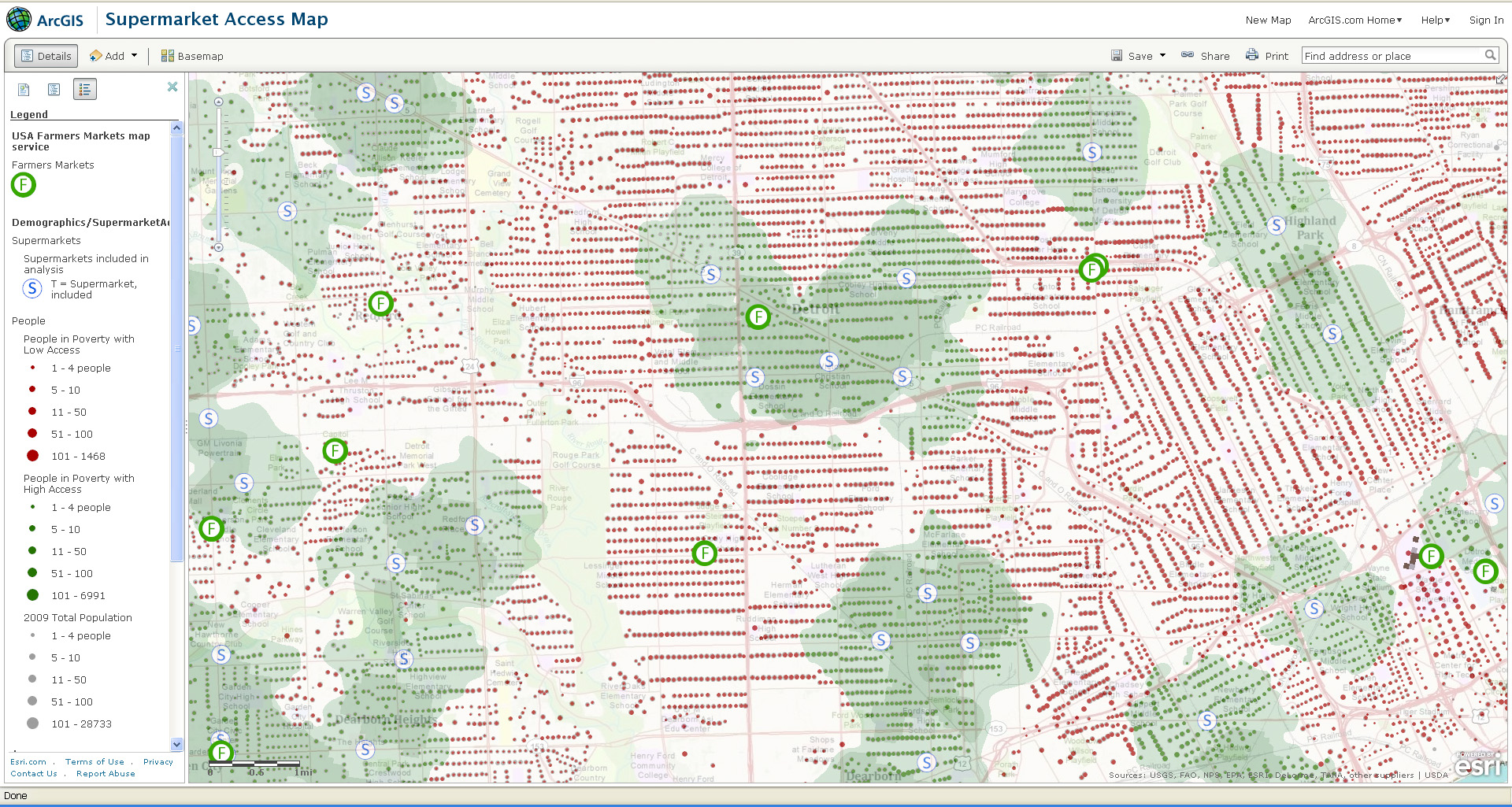
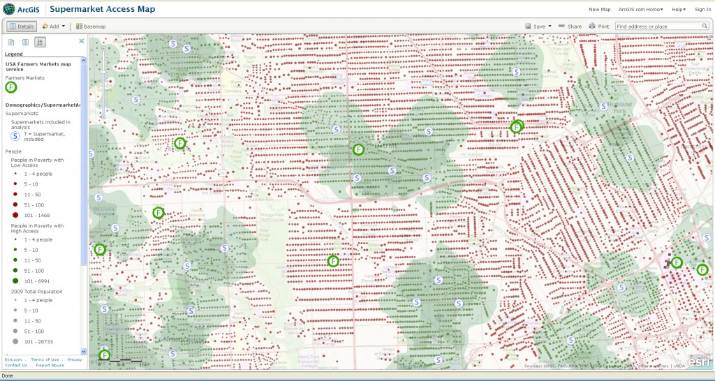
ESRI’s ArcGIS Online Supermarket Access Map – click here

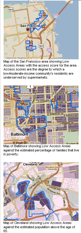
TRF’s PolicyMap Data on Supermarket Access – click here


Sample map from ESRI’s Supermarket Access Map:
 

Sample maps from TRF’s PolicyMap application:
 

Categories
Bucknell/Local Interest Data Digital Humanities Environment Events/Calendar General GIS Slideshow

Details on $520K Mellon grant for environmental studies, GIS integration

I posted a few weeks ago about the $520K grant awarded to Bucknell by the Mellon Foundation. Here are some additional details on how the grant money will be used to strengthen environmental studies and GIS integration across the university. From the Library & IT Matters newsletter:

  • Up to twelve faculty members will receive $400 to participate in either a 4-day (intro) or 2-day (advanced) summer GIS workshop. Click here for more details on the intro and advanced workshops.
  • Faculty members may submit requests to receive up to $1,000 to revise a course to include GIS ($5,000 total)
  • Four student researchers will be provided with summer research funding to conduct research projects involving GIS technology
  • Funds will be available to support consultants and student workers to create new maps or to develop new datasets for use by faculty in integrating GIS for their curriculum and courses
  • Additionally we have support to help with the acquisition of data which can only be obtained through purchasing data sets or through membership in consortia which provide access to proprietary datasets

Contact me by e-mail at janine.glathar@bucknell.edu or by phone at x. 1990 if you are interested in any of the options listed above.

Categories
Bucknell/Local Interest Events/Calendar General GIS Slideshow

Call for faculty participation in LIT and Mellon-funded summer GIS workshops

Call for faculty participation in LIT and Mellon funded summer GIS Workshops

Two GIS workshops for faculty will be offered during Summer 2011.
* Introductory GIS workshop (4 days)
Monday, August 8th through Thursday, August 11th from 9am-1pm*
(lunch provided)

* Advanced GIS workshop (2 days)
Monday, August 15th through Tuesday, August 16th*
(lunch provided)

*Additional workshop dates (e.g. end of May/early June) may be added depending on faculty interest. If you are interested in attending, but can’t join us during the August workshop dates, please click on the link below to suggest alternate dates.

These grant supported workshops ($400 for each participant) will enable 12 faculty to engage in a hands-on GIS experience designed to be broadly useful to faculty, regardless of their specific disciplines and areas of research. To make the workshop experience more meaningful and relevant, both the introductory and advanced workshops will feature local data and topics of interest

If you are interested in participating, please click the link below to complete the GIS workshop interest form. Please note – there is a limit of 12 funded seats for the Summer 2011 GIS Workshops. Additional Mellon funded GIS workshop opportunities will be announced prior to summer 2012 and 2013 sessions.

Click here to access GIS workshop interest form.

Categories
Bucknell/Local Interest Events/Calendar General GIS Marcellus Shale Slideshow

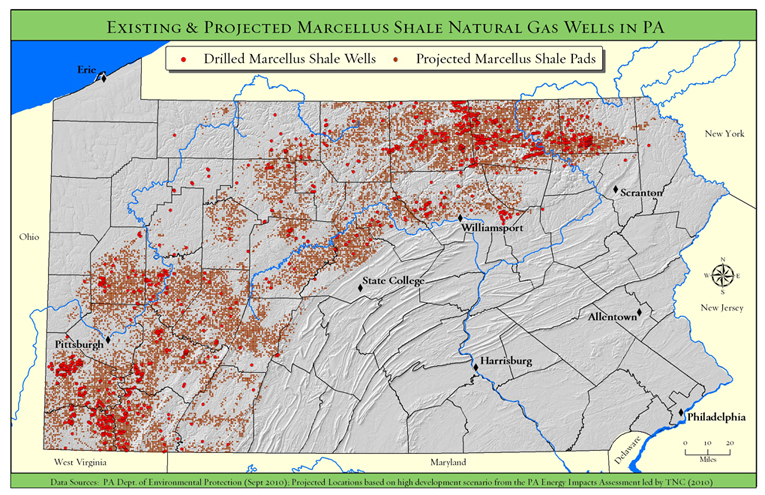
TNC Presentation on Marcellus Shale – Monday, April 4 @ 4:30pm

What: Presentation by The Nature Conservancy on Marcellus Shale/PA Energy Impacts
When: Monday, April 4th at 4:30pm
Where: Bertrand Library, Traditional Reading Room

Refreshments will be served.

Come and hear Tamara Gagnolet, GIS Analyst and Conservation Data Manager for the Pennsylvania chapter of the Nature Conservancy, discuss her work in using GIS to analyze potential impacts of Marcellus Shale gas drilling in Pennsylvania. Ms. Gagnolet’s presentation will focus on how GIS and spatial analysis were used to project how much energy might be developed in PA during the next 20 years, where that development is more or less likely to occur and what types of strategies might need to be employed to mitigate potential habitat impacts.

Students are welcome and encouraged to attend.