Categories
Bucknell/Local Interest General GIS Slideshow

Call for faculty interest in summer 2012 GIS workshops at Bucknell (revised)

As we have for the past two summers, Bucknell’s LIT division will offer a series of summer workshops for faculty interested in hands-on instruction in GIS. Stipends of $400 will be offered to faculty for participating in each workshop. Please fill out this interest/registration form as soon as possible if you are interested in any of the following workshops.

Overview

1. Introductory GIS workshop (4 days, 4 hours per day) – no prerequisites
Monday, August 6th-Thursday, August 9th from 9am-1pm (lunch included)
2. Using ArcHydro for Water Resources Analysis (3 days, 8 hours per day)*
Monday, August 13th-Wednesday, August 15th from 9am-1pm (lunch included)
3. Spatial Statistics with ArcGIS and Geoda (2 days, 8 hours on 1st day, 4 hours on 2nd day)*
Thursday, August 16th from 9am-4pm and Friday, August 17th from 9am-1pm (lunch included)

Details – Spatial Statistics with ArcGIS & Geoda

The workshop ‘Spatial Statistics with ArcGIS and Geoda’ will be taught by Professor Jennifer Miller, Assistant Professor in the Department of Geography & Environment and Director of the GIScience Center at University of Texas at Austin. Below is a tentative outline of the 3-day workshop. Faculty will have an opportunity to work with their own data for part of the last day of the workshop.

Day 1: Introduction to Spatial analysis and Point pattern analysis

  • 1st order vs 2nd order effects (density vs. distance)
  • Nearest neighbor analysis, Ripley’s K statistics
  • Interpreting results (z-scores, Monte Carlo simulation)

Day 2: (Global) Spatial pattern measurement and modeling

  • Spatial autocorrelation analysis
  • Conceptualizing spatial relationships
  • Moran’s I, Getis-Ord General G statistic
  • OLS Regression
  • Model fittingModel diagnostics
  • Residual analysis

Day 3: (Local) Spatial pattern measurement and modeling

  • Local spatial autocorrelation analysis
  • LISA, Gi* (Geoda software)Mapping/interpreting results
  • Geographically weighted regression
  • Spatial non-stationary

Details – Using ArcHydro for Water Resources Analysis

The workshop ‘Using ArcHydro for Water Resources Analysis’ is tentatively scheduled to be taught by Professor Venkatesh Merwade, Assistant Professor in the School of Civil Engineering at Purdue University and Director of the Geospatial Water Resources Institute.  We are close to finalizing details on this workshop, so stay tuned for details on who will teach the workshop. Below is a tentative outline of the 3-day workshop. Faculty will have an opportunity to work with their own data for part of the workshop.

  • ArcGIS Skills Review
  • Integrating Geospatial and Temporal Datasets for Hydrology
  • Raster and Vector Data in Hydrology
  • Terrain Analysis in ArcGIS (Hydrology Tools)
  • Terrain Processing Using ArcHydro
  • Developing SCS Curve Number Grid
  • HEC-GeoHMS Application
  • HEC-HMS Application
  • HEC GeoRAS Application
  • HEC-RAS Application
  • Building ArcHydro Network using NHD
  • Groundwater Tools in ArcGIS
Categories
Bucknell/Local Interest Data General GIS GIS Jobs, Internships, Scholarships & Grad Programs Slideshow

GIS Job Opportunities – Smith College

In recent weeks I’ve talked to a number of second semester seniors about GIS job options.  I’m hoping at some point to write a blog post with links to GIS job search sites and other resources, but for now I’m just going to pass along job listings as I see them.

I just got an e-mail from Jon Caris, the GIS Specialist at Smith College in Northampton, MA saying that Smith is looking to hire a new or recent college graduate (within 3 years) for the brand new Post-Baccalaureate Spatial Analysis Fellow position.  Start date is July 2012 – direct link to the posting can be found here.  This position is ideal for a student hoping to gain additional GIS experience before looking for a permanent job, or as a bridge before graduate school. Duties are similar to what the team of GIS Student Assistants do at Bucknell and include:

  • Data Documentation, Maintenance, and Acquisition
  • Equipment and Software Maintenance
  • Class & Individual Support
  • Administrative Support

If this sounds interesting to you please talk to me. Jon is doing a whole bunch of really innovative things with GIS at Smith and would be an incredible mentor to work with!

Categories
Bucknell/Local Interest Digital Humanities Environment General GIS GIS in Computer Science GIS in Environmental Studies GIS in Geography GIS in Geology GIS in Public Health GIS in Sociology Slideshow

From the Yale Daily News… “Map on, Maples!”

The Yale Daily News has a great article about the role that the GIS Specialist, Stace Maples, plays on campus. Maples, a fellow ESRI T3G Institute alum from summer 2010, works with faculty and students on integrating GIS into teaching and research at Yale and…

… he is in high demand. Working in the three-person Map Department, a department within the Yale University Library, he trains students and faculty in the use of the arcane computer program. He helps professors in areas from history to public health, in such projects as diverse as mapping correspondence networks and placing photographic collections in a geological context. He is adamant that geographical data is relevant to all academic endeavors.

“Everything is somewhere, and that somewhere matters,” Maples declared.

Although I take issue with the reporter’s use of the word ‘arcane’ to describe GIS software, I’ll second Stace’s assessment that location matters (or, as the Geospatial Revolution team at Penn State put it, “the location of anything is becoming everything“).  In a statement that is sure to resonate with faculty, Peter Bol, the director of the Center for Geographic Analysis at Harvard University, is quoted in the article as saying that:

 “If you want to publish competitive research today, you have to have GIS.”

That might be a bit of an overstatement (for the moment, at least), but there’s no doubt that incorporating GIS and spatial analysis is increasingly becoming an expectation in academic research, much in the same way as it has become part of the fabric of our everyday lives.  Dana Tomlin – who is… a visiting faculty member in the Yale School of Forestry, co-director of the Cartographic Modeling Laboratory at the University of Pennsylvania, a GIS Hall of Fame-r, the creator of map algebra, and, incidentally, the grad school professor who got me hooked on GIS (thanks, Dana!), sums it up this way:

“With the advent of web mapping services like Google Earth and Bing, the ability to sense geographical position in real time via the Global Positioning System (GPS), and the opportunity to place this sort of magic quite literally into the hands of anyone with a smart phone, there is no question that the world at large is already well beyond the point of no return in terms of making routine use of geographical data in digital form.”

GIS has existed as a computing technology since the 1960’s, but until the mid to late 1990’s it was largely the domain of highly-trained specialists working from high-powered servers. GIS software and web-based map apps have become increasingly faster, more powerful and more user-friendly over the last 20 years. If those trends continue, and if we do our jobs well, Stace and I might very well work ourselves out of a job:

It is conceivable that GIS might one day become as ubiquitous within academia as Google Maps is within the broader population. If departments integrate GIS into their own teaching, the role that Maples and other specialists play is likely to diminish. Graduate students in fields employing GIS are expected to understand the program and its functionalities… Meanwhile, academics who only rarely use GIS might consult specialists if and when necessary, while remaining blissfully oblivious of the program’s nitty-gritty.

Today’s graduate students are tomorrow’s professors. And, if the trends hold true, at least a significant proportion of them will soon be using GIS technology to gain deeper insight into diverse fields of study for decades to come. So map on, Maples.

Click here to read the full story and learn more about how Yale faculty and students are using GIS to study history, archaeology, linguistics, environmental studies, forestry, public health and other topics.


Categories
Bucknell/Local Interest Events/Calendar General GIS Marcellus Shale Slideshow

TNC Presentation on Marcellus Shale – Monday, April 4 @ 4:30pm

What: Presentation by The Nature Conservancy on Marcellus Shale/PA Energy Impacts
When: Monday, April 4th at 4:30pm
Where: Bertrand Library, Traditional Reading Room

Refreshments will be served.

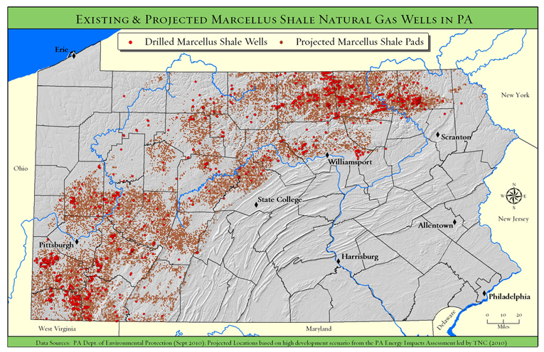
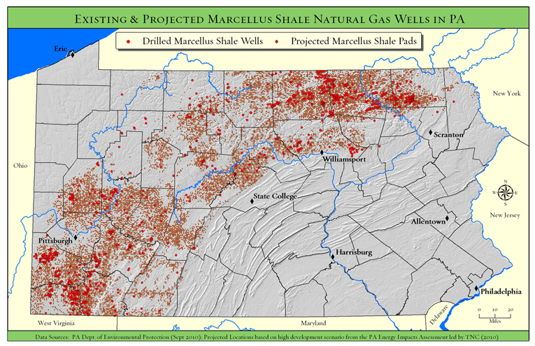
Come and hear Tamara Gagnolet, GIS Analyst and Conservation Data Manager for the Pennsylvania chapter of the Nature Conservancy, discuss her work in using GIS to analyze potential impacts of Marcellus Shale gas drilling in Pennsylvania. Ms. Gagnolet’s presentation will focus on how GIS and spatial analysis were used to project how much energy might be developed in PA during the next 20 years, where that development is more or less likely to occur and what types of strategies might need to be employed to mitigate potential habitat impacts.

Students are welcome and encouraged to attend.

Categories
Bucknell/Local Interest Environment Events/Calendar General GIS Marcellus Shale

Upcoming presentation by The Nature Conservancy

Back in December I posted links to a new report and webinar by the Nature Conservancy describing their use of GIS to analyze potential Marcellus Shale impacts in PA.  At some point in April we’ll have the Nature Conservancy team here at Bucknell for a presentation of their work.  Stay tuned for more details…