Categories
Bucknell/Local Interest Data Digital Humanities General GIS Slideshow

GIS & Bucknell’s Administration

Guest post by Dan Dougherty, Geography/History ’12
The GIS team did not only work on projects for faculty and staff members. Bucknell’s Administration was also interested in several mapping projects. Some are highlighted below:

Bucknell Parking
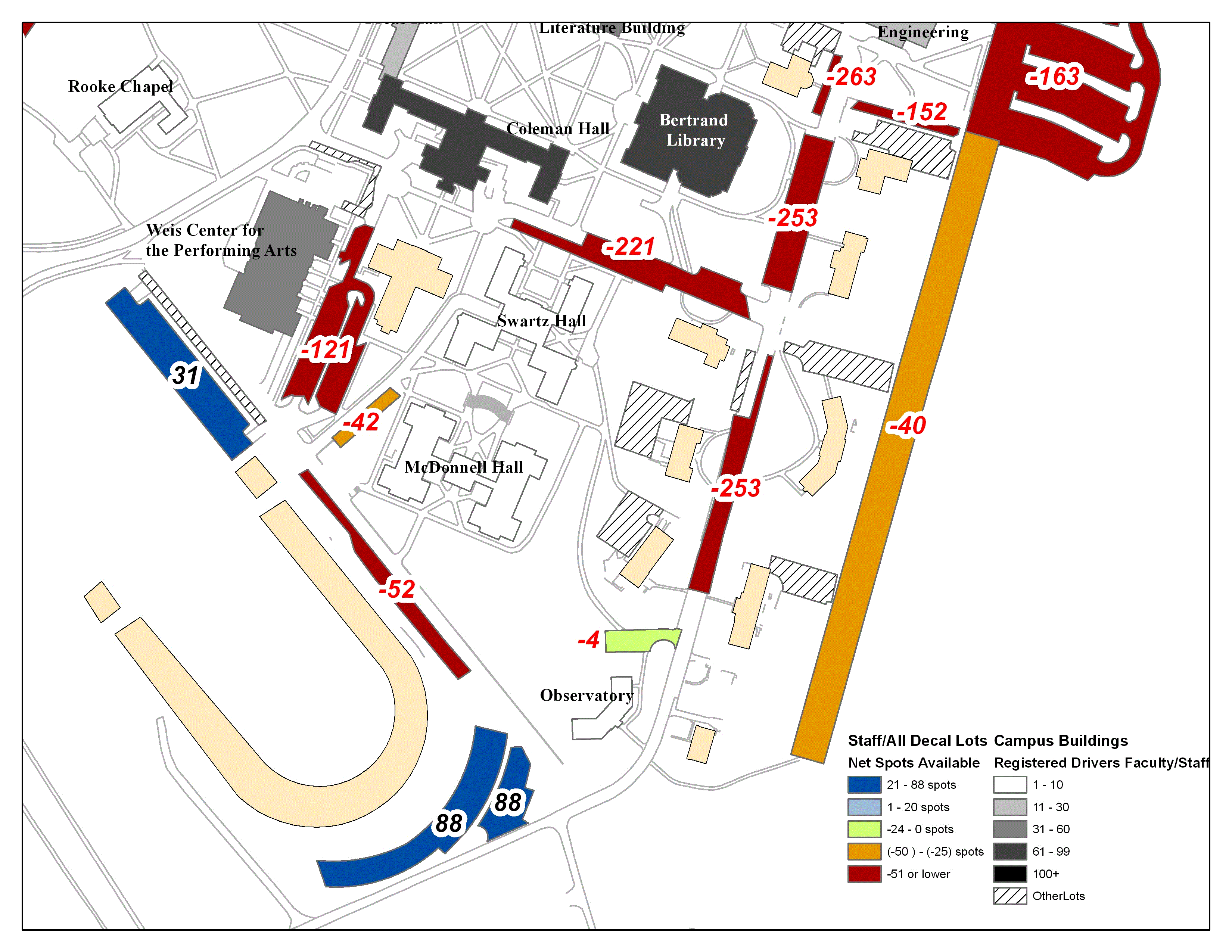
The continued growth of the University, coupled with limited space available for small scale expansion projects, has created a significant amount of vehicular congestion on campus. The amount of cars present has resulted in an increasing dearth in parking spaces. In order to analyze current trends and make recommendations for the future of parking on campus, Bucknell’s Administration asked for a series of GIS maps showing the current state of on-campus parking. The maps were produced in ArcMap 10, and the end result revealed that the parking situation in campus is much worse than expected. On any given day during the academic year, total lot capacity can be estimated at nearly 100%. A series of five maps were produced showing the entire campus; below are two of them.
Task Force on Campus Climate
Recent events on campus have encouraged the Administration to take a tougher stance against some of the negative behaviors associated with college social interaction. The Task Force on Campus Climate asked for GIS maps showing trends in reported incidents on campus. Since only a minority of events are reported to the Task Force, the map cannot be relied upon to provide the most up to date and accurate information, but nonetheless they provide a good starting point for future policy making regarding student safety on campus.

Bucknell SBDC
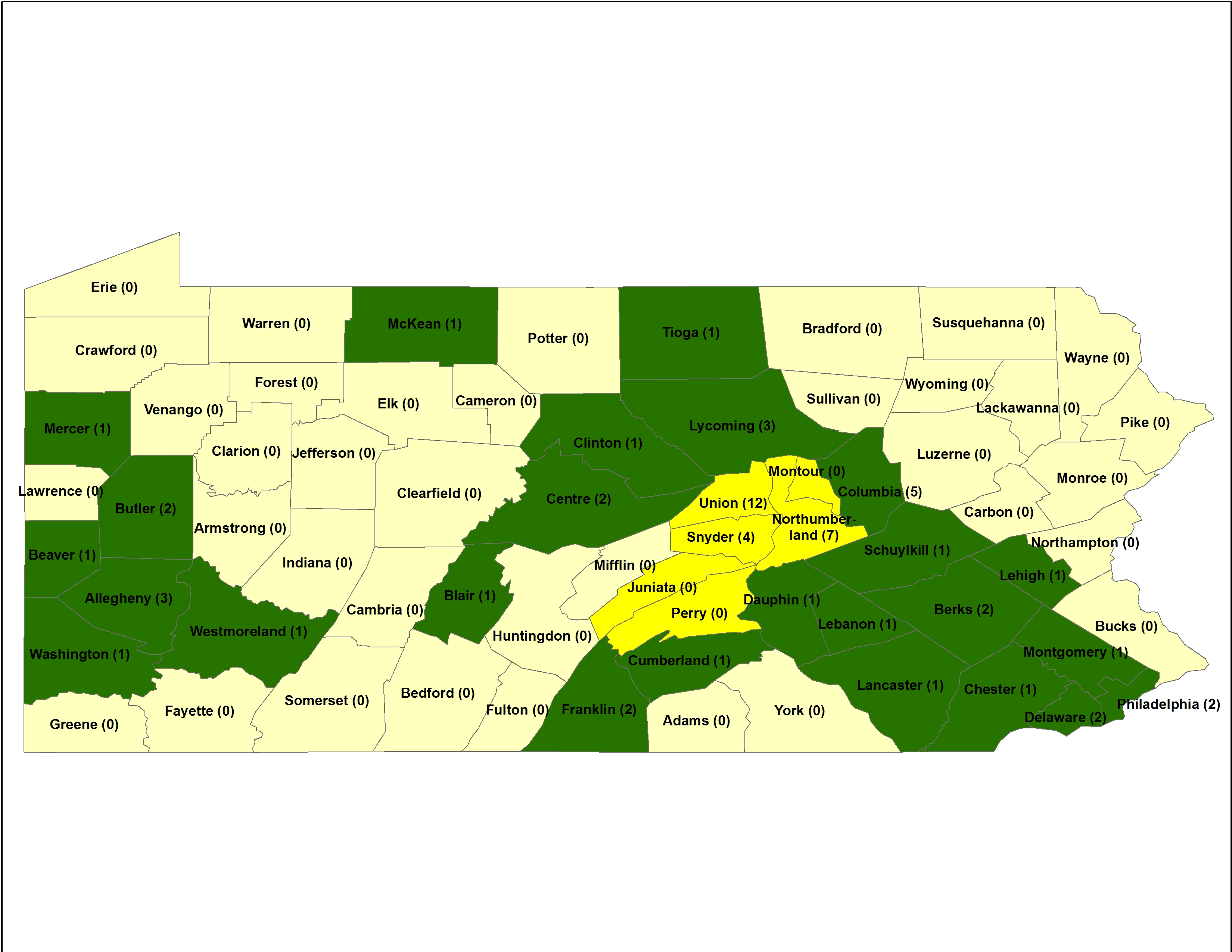
The Bucknell Small Business Development Center requested an update to a map which was made by a member of the GIS team during the previous summer. The Bucknell University SBDC helps business Start, Grow, and Prosper by providing entrepreneurs with the education, information and tools necessary to build successful businesses. Bucknell’s center is the first in the nation to be hosted by an engineering college and provides specialty Engineering Development Services throughout the Pennsylvania SBDC network. The map shows the number of Engineering Development Services (EDS) per county, with the symbology showing the regional grouping (yellow) and the the counties with affiliated EDS (green)
Categories
Bucknell/Local Interest Data Digital Humanities Environment Events/Calendar General GIS Marcellus Shale Slideshow

GIS Students Showcase Their Summer Work at Two Symposiums

Guest post by Dan Dougherty, Geography/History ’12
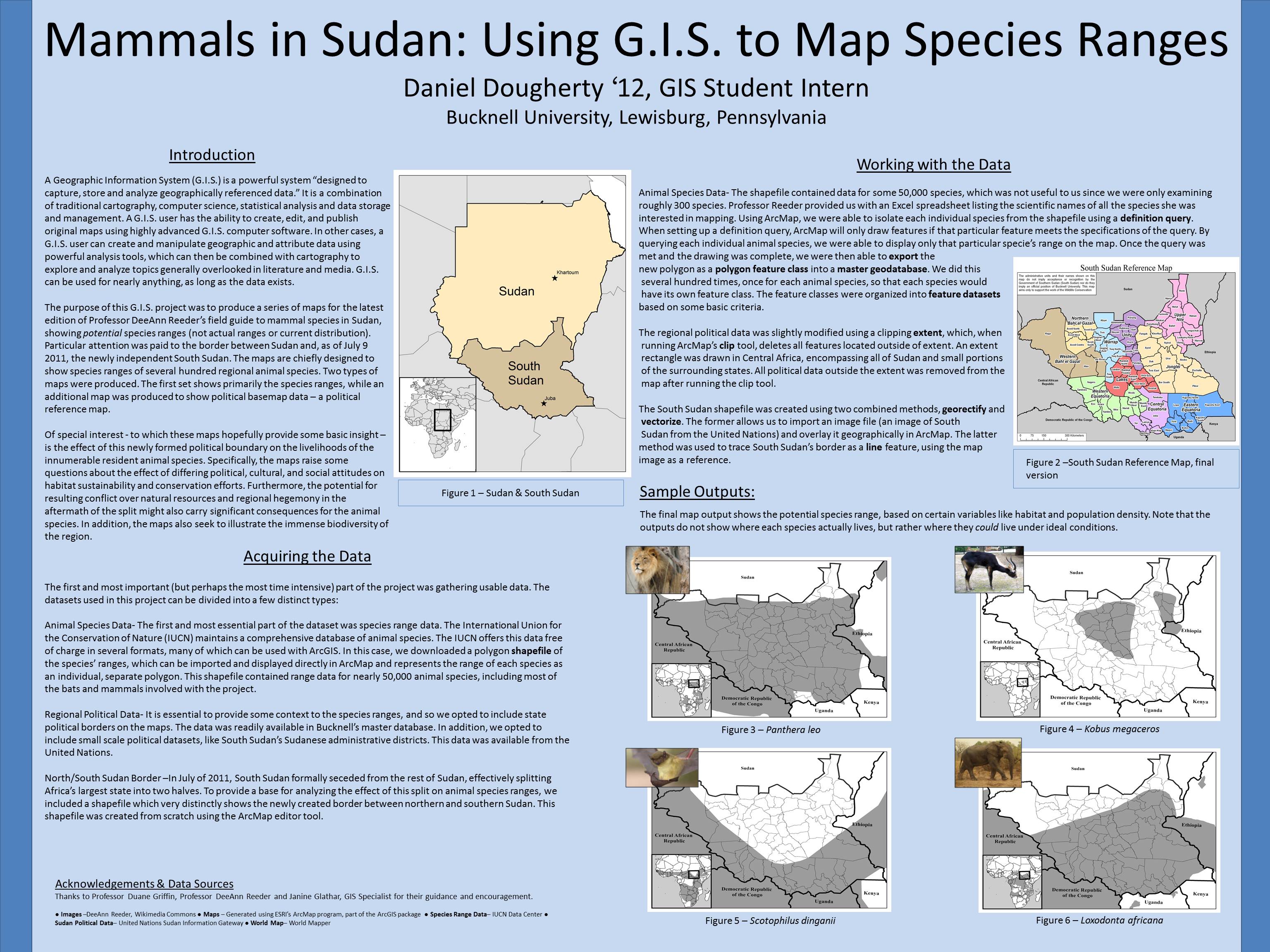
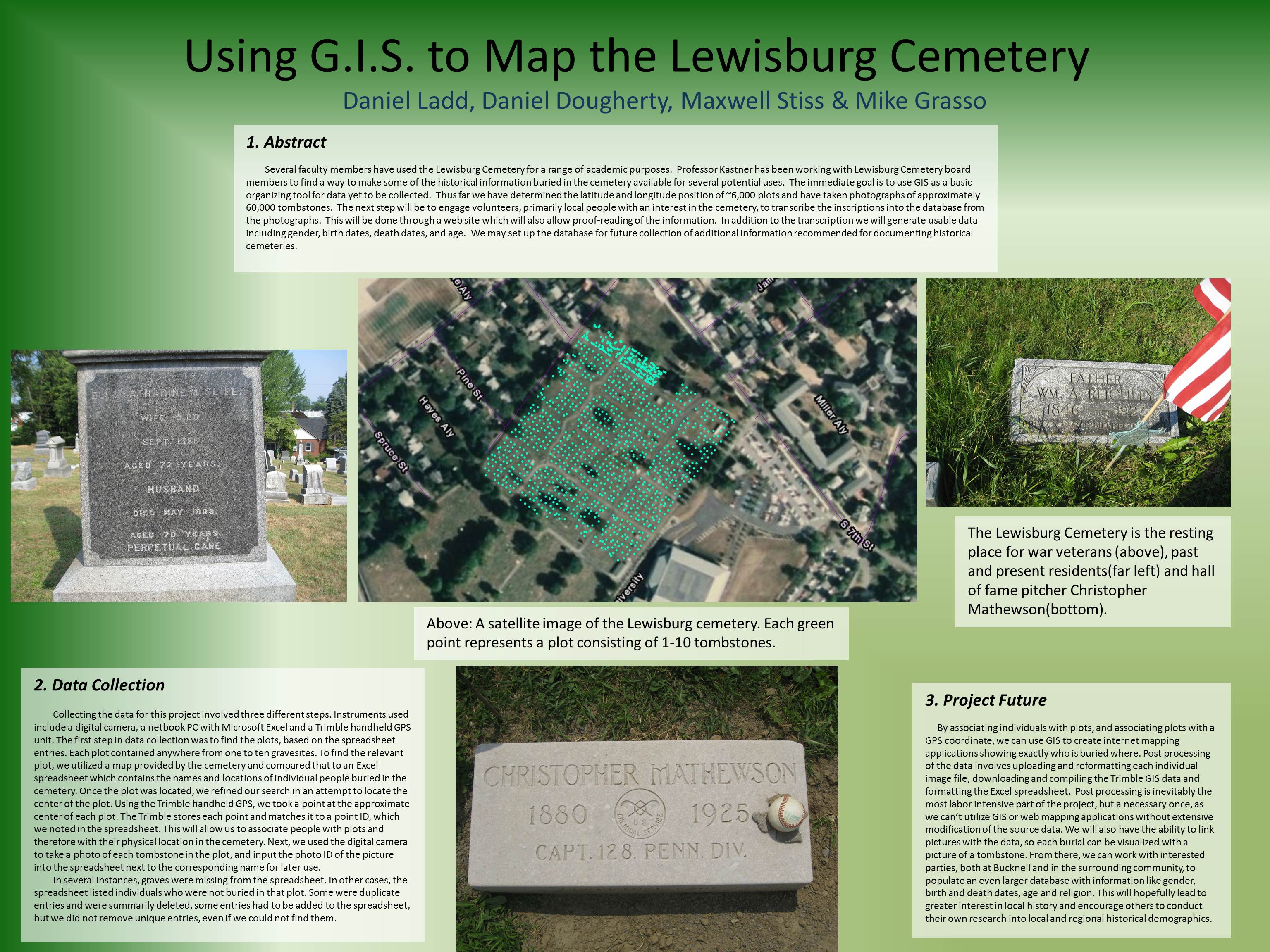
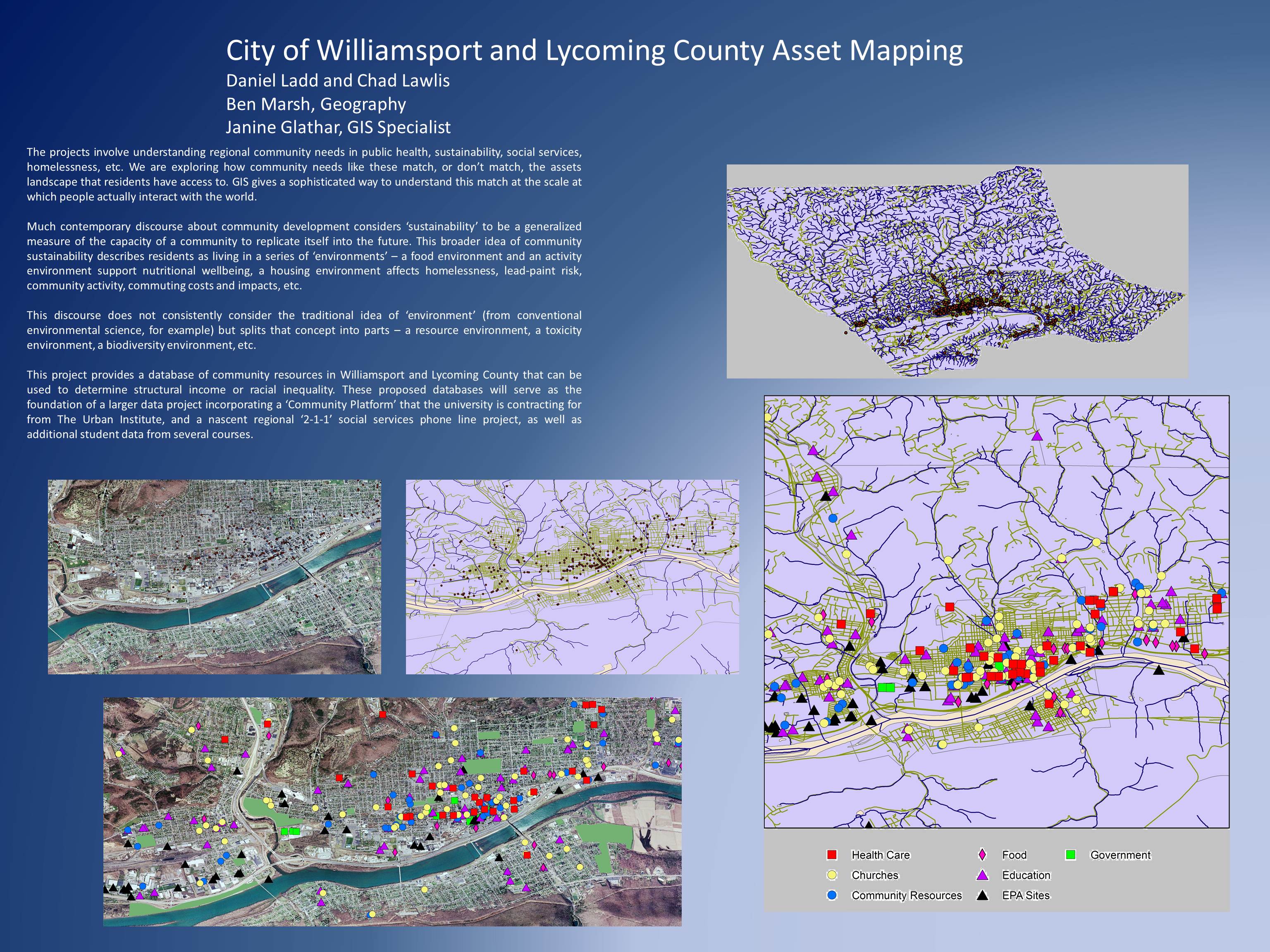
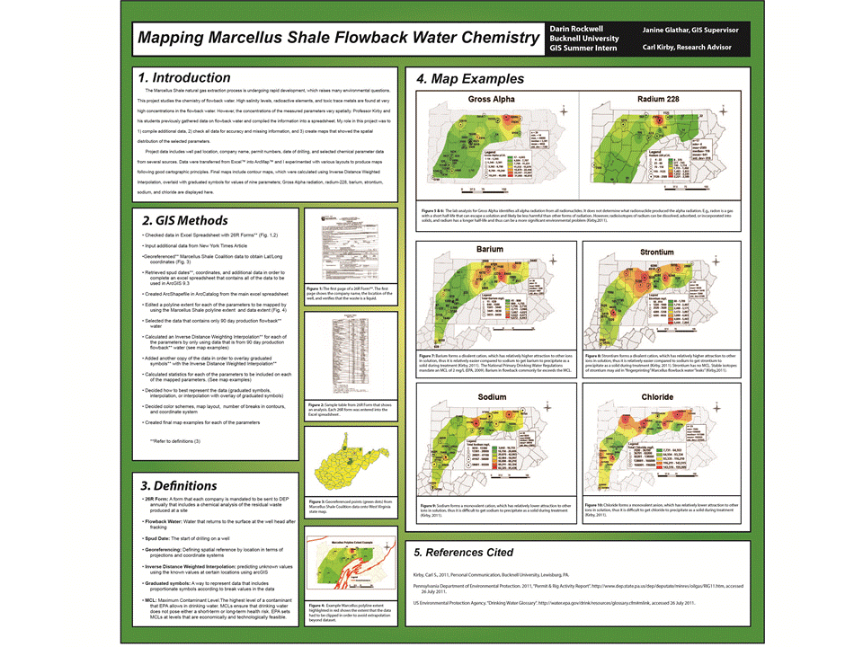
Bucknell’s summer GIS students recently got the opportunity to showcase their work at two separate poster symposiums. It helps to know a little bit about research/poster symposiums, for those who are unfamiliar. They are fairly straightforward. Participants set up their posters in a preassigned display location. Standing close by their posters, students field questions from interested attendees who wander the showcase, viewing posters of interest. The posters generally outline the basics of the research project first, before moving on to explain the more detailed aspects, like methodology and an analysis of the results. Space is limited so not everything can (and should!) be explained on the poster – and the student therefore must be prepared to answer fully any questions an attendee might ask. Many poster sessions are judged, with the winner awarded a prize (usually monetary). However, neither symposium the GIS students attended was judged.

GIS students attended their first symposium on Wednesday, July 27, 2011. The Sigma Xi Poster Session was held in Bucknell’s Terrace Room, located in the Elaine Langone Center. Approximately 50 students presented their work; six GIS students with eight separate posters were among them. Dozens of people turned out to view the posters, including Bucknell faculty, administrators, and members of the local community. Provost Mick Smeyer was among the attendees, and was so impressed with the quality and consistency of the work that he asked all attendees to repeat the session again in September for Bucknell’s President, John Bravman, and the Board of Trustees.

Students attended a second symposium on August 9, 2011 from 10am to 3pm. The First Annual Susquehanna Valley Undergraduate Research Symposium was held at the Geisinger Center for Health Research in Danville, Pennsylvania, about 30 minutes from Bucknell’s campus. Students from both Bucknell University and Bloomburg University were in attendance to showcase their summer research projects to their peers, interested academics, and Geisinger staff members. Bucknell’s GIS students contributed seven posters to the symposium, all of which received substantial praise and recognition.

Categories
Bucknell/Local Interest Data Digital Humanities Environment General GIS GIS in Biology GIS in Computer Science GIS in Engineering GIS in Environmental Studies GIS in Geography GIS in Geology GIS in History GIS in Humanities GIS in Psychology GIS in Sociology Map Apps Marcellus Shale Miller Run Restoration Project Slideshow

What we’re up to this summer (and why we’re not posting)

Thanks to the Mellon grant and a huge number of faculty teaching and research projects it’s been a very busy summer of GIS work at Bucknell.  Over the coming weeks I’ll write detailed posts about the work we’re doing on each of the projects.  If I’m really ambitious I might try to post some interviews with faculty and students – and some footage of the aerial drone flights that Nick Urban ’12 is doing. But for now here’s a short overview of who’s doing GIS work at Bucknell this summer and what we’re doing:

GIS Student Assistants:

  • Chad Lawlis, Environmental Studies ’11
  • Dan Dougherty, Geography/History ’12
  • Max Stiss, Geography/Anthropology ’12
  • Nick Urban, Computer Science ’12
  • Mike Grasso, Environmental Studies ’13
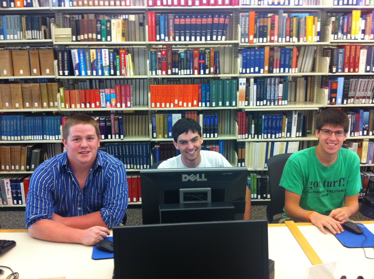
  • Robby Holler, Geography/International Relations ’13 (pictured below)
  • Darin Rockwell, Geography/Geology ’13 (pictured below)
  • Dan Ladd, Middlebury College ’14 (pictured below)

Key Projects:

  • Maps for Sudan field guide atlas to mammals
  • GPS data collection for Lewisburg Cemetary
  • GPS data collection for Miller Run restoration project
  • Aerial drone data collection for Miller Run restoration project
  • Lycoming County/Williamsport community asset mapping
  • Mapping toxic contamination from Marcellus Shale natural gas wells
  • Mapping locations of Marcellus Shale water withdrawl permits
  • Georeferencing & vectorizing 19th century economic maps of Vietnam
  • Georeferencing & vectorizing maps of environmental hazards and resources in Kyrgyzstan
  • Georeferencing & vectorizing 1868 Historic Atlas of Union & Snyder Counties
  • Data development for Stories of the Susquehanna project
  • Support for student research projects – including GPS’ing dumpster locations on campus for an analysis of campus waste and recycling, and updating Arboretum tree dataset with location info for newly planted and felled trees
  • Develop pilot web map apps for showcasing faculty research
  • Develop pilot web map apps for use in teaching
  • Implement backend IT infrastructure to support ArcGIS server
  • Maps for Bucknell admin purposes, including: analysis of parking shortages on campus; maps for task force report on campus climate; maps for SBDC report on services by county; arts festival map.


Categories
Bucknell/Local Interest Digital Humanities General GIS GIS in Environmental Studies GIS in Geography GIS in History GIS in Humanities Map Apps Marcellus Shale Slideshow Videos

Uncovering the ‘Stories of the Susquehanna’ using GIS

Bucknell faculty have long had an interest in grounding their research efforts locally – using the physical, cultural, historical and sociological landscapes of the Susquehanna Valley region as a living laboratory. The two videos below feature Prof. Katherine Faull and student Emily Bitely ’11 talking about the role of GIS in two such projects – the Stories of the Susquehanna, and the John Smith Trail Extension project (both multi-year, inter-disciplinary projects involving faculty from across the campus).

Katie Faull discussing her use of GIS for the John Smith Trail Extension and Stories of the Susquehanna project:
httpv://www.youtube.com/watch?v=j2eG2v8FnOA

Emily Bitely ’11 discussing her use of GIS for the same projects:
httpv://www.youtube.com/watch?v=1uPcaaqSzII

More about the John Smith Trail:

  • To learn more about the John Smith Trail, click here or here.
  • To view a National Geographic map detailing Captain John Smith’s voyage, click here.
  • To view a map of interpretive ‘smart’ buoys located in the river, click here.

More about the Stories of the Susquehanna project:

  • A pilot web mapping application featuring two of the ‘Stories of the Susquehanna’ is scheduled to launch this fall.  Stay tuned for more details.
  • Click here to read about the 2010 Susquehanna Valley Summer Writer’s Institute (SVSWI).  The SVSWI project is related to the Stories of the Susquehanna both in the type of local stories it explores and in its use of maps, audio, video, images and text to reflect on those stories in an interactive digital story-telling environment.
  • Click here to view the SVSWI’s interactive mapping application featuring students’ reflections on the impact of the Marcellus Shale gas boom on different populations in the Susquehanna Valley region.
Categories
Bucknell/Local Interest Data Digital Humanities Environment Events/Calendar General GIS Slideshow

Details on $520K Mellon grant for environmental studies, GIS integration

I posted a few weeks ago about the $520K grant awarded to Bucknell by the Mellon Foundation. Here are some additional details on how the grant money will be used to strengthen environmental studies and GIS integration across the university. From the Library & IT Matters newsletter:

  • Up to twelve faculty members will receive $400 to participate in either a 4-day (intro) or 2-day (advanced) summer GIS workshop. Click here for more details on the intro and advanced workshops.
  • Faculty members may submit requests to receive up to $1,000 to revise a course to include GIS ($5,000 total)
  • Four student researchers will be provided with summer research funding to conduct research projects involving GIS technology
  • Funds will be available to support consultants and student workers to create new maps or to develop new datasets for use by faculty in integrating GIS for their curriculum and courses
  • Additionally we have support to help with the acquisition of data which can only be obtained through purchasing data sets or through membership in consortia which provide access to proprietary datasets

Contact me by e-mail at janine.glathar@bucknell.edu or by phone at x. 1990 if you are interested in any of the options listed above.