Categories
Bucknell/Local Interest Data Environment General GIS GIS in Computer Science GIS in Engineering GIS in Environmental Studies GIS in Geology Miller Run Restoration Project Slideshow

Keystone Edge story about the Flying Bison

The online journal, Keystone Edge, recently picked up the story of Nick Urban and the Flying Bison drone.  Published by Issue Media Group, the Keystone Edge

… tells the story of the new economy in Pennsylvania–a narrative of creative people and businesses, new development, cool places to live, and the best places to work and play. Each Thursday, the Web site and weekly online magazine presents original stories, video and photography to tell that story, from Pittsburgh to Philly.

An excerpt from the story is included below. Check out the full story here.

Innovation & Job News – Bucknell student’s remote-controlled plane captures imagery to aid creek restoration – THURSDAY, SEPTEMBER 01, 2011

Remote-controlled cars and airplanes were a hobby of Nick Urban’s when he was a boy. That interest remained as he pursued a computer science degree atBucknell University, where he spent this summer building a remote-controlled plane that’s being used to map the landscape around a creek that runs through Bucknell’s campus and into the Susquehanna River. The plane, dubbed the “Flying Bison,” was built of foam, includes Geographic Information System technology and can navigate predetermined paths on autopilot. Digital still and video cameras were attached to the plane so it could capture images of the Miller Run Creek as it flew around the waterway.



Categories
Bucknell/Local Interest Data Environment General GIS GIS in Geography GIS in Psychology GIS in Public Health GIS in Sociology Slideshow

Williamsport and Lycoming County Asset Mapping

Guest post by Dan Ladd, Middlebury College ’14

One of the major projects the GIS team worked  on for much of the early part of the summer was mapping community assets in Williamsport and Lycoming County. This project was requested by Professors Ben Marsh (Geography) and Carl Milofsky (Sociology). Chad Lawlis (Environmental Studies ’11) and I worked on putting together the information for this project.

The project involved understanding regional community needs in public health, sustainability, social services, homelessness, etc. We explored how community needs like these match, or don’t match, the assets landscape that residents have access to. GIS gives a sophisticated way to understand this match at the scale at which people actuallyinteract with the world.

Much contemporary discourse about community development considers ‘sustainability’ to be ageneralized measure of the capacity of a community to replicate itself into the future. This broader idea of community sustainability describes residents as living in a series of ‘environments’ – a food environment and an activity environment support nutritional well-being, a housing environment affects homelessness, lead-paint risk, community activity, commuting costs and impacts, etc.

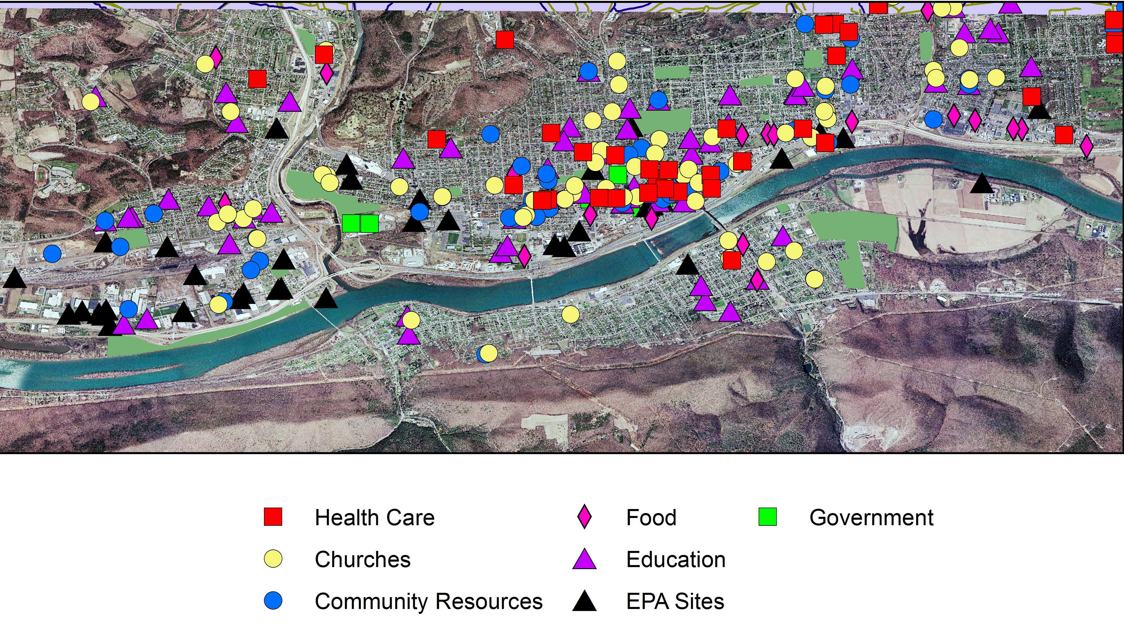
Data was collected on different Community Asset Classes (Churches, Healthcare providers, Food store, schools etc.). This information ranged from street address, contact information and a classification of what services each asset provided. These assets were then combined and mapped to give an idea of the spacial distribution of these assets.


Williamsport Community Assets

This project also serves as a template for future community asset data collection projects as the eventual goal is to expand this information to cover the Greater Central Susquehanna Valley. These proposed databases will serve as the foundation of a larger data project incorporating a ‘Community Platform’ that the university is contracting for from The Urban Institute and anascent regional ‘2-1-1’ social services phone line project.


Categories
Bucknell/Local Interest Data Environment General GIS GIS in Computer Science GIS in Engineering GIS in Environmental Studies GIS in Geography GIS in Geology Slideshow Videos

Computer science major builds aerial drone for a bird’s-eye view of local stream

Bucknell communications recently published an article on the work that Nick Urban and the other GIS student assistants did this summer for the Miller Run Restoration project.  Excerpt below – click here to read the full article.

LEWISBURG, Pa. – As the son of an aircraft mechanic, Nick Urban learned a thing or two about planes.

The rising senior at Bucknell University started out putting together model airplanes when he was a child but later became more interested in the technology that makes them work.

This summer, Urban, a computer science major from New Jersey, has combined the two interests in a research project in which he is designing, building and flying a remote-controlled aerial drone. The so-called “Flying Bison,” outfitted with video and still cameras and GIS technology, is being used to capture high-resolution images of Miller Run Creek for an ongoing restoration of the waterway that runs through Lewisburg. The data also will be used to assess how well unmanned aerial vehicles monitor environmental change.

“Pretty much all the equipment you would find on a regular plane is squeezed onto this remote-control plane,” Urban said during a recent test flight at the Bucknell University Golf Course. “It has a manual takeoff and landing, but I flip a switch on the transmitter and it will fly itself and navigate on its own.”

Categories
Digital Humanities General GIS GIS in History Slideshow

Using G.I.S. to Visualize Historical Landscapes

Guest post by Michael Grasso, Environmental Studes 13′

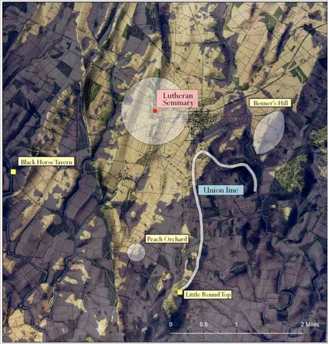
Geographic Information Systems can be used recreate a landscape that no longer exists. Historians can use this technology to help explain confusing, or even previously unexplainable, events that took place in the past. For example, General Robert E. Lee issued a series of orders (Pickett’s Charge) that directly caused the Confederates to lose the battle of Gettysburg and inevitably the Civil War. If anyone stood today where General Lee stood that fateful day they would be able to clearly see the fortified, superior Union force waiting for the charge – and wonder why Gen. Lee made the decision that he did. However, the landscape has dramatically changed in the 150 years since the Civil War.  Using historical maps and other documentation, geographers and historian were able to re-create the landscape that General Lee saw and to determine that – from his position 150 years ago -one could not see the eastern end of the battle field where Union forces were amassing.

This is a link to an article explaining how G.I.S. was used to answer questions be recreating historical landscapes such as the Battle of Gettysburg, the 1930s dust bowl, and the Salem Witchcraft Trials.

Categories
Crisis-Mapping Environment General GIS GIS in Political Science Slideshow

Using G.I.S. to Help Analyze and Visualize Disasters

Guest post by Michael Grasso, Environmental Studies ’13

G.I.S. has an extremely large variety of applications. With G.I.S. one could map an area affected by a natural disaster in order to analyze the extent of the damage, the value of the property damaged, and how different areas were affected differently. G.I.S. can even be used just to help someone visualize the totality of the damage that occurred.

One such disaster that has been mapped was the F5 tornado that ravaged Joplin, Missouri on May 23, 2011. There are many different maps that are available to the public that can used for different applications.

This link is a google map created using G.I.S. that one could use to assess what property was damaged or completely destroyed. It also labels different areas based on an average amount of damage as well as marking where the tornado begins, changes in intensity and direction, and when it dissipates.


This link is primarily to help someone visualize the affects of the tornado. This map was created using G.I.S. and is basically a before and after picture where you can zoom into different areas.
http://gis.wustl.edu/Joplin.HTML


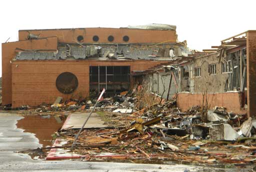
This is a picture of the Joplin High School after the tornado’s destruction