Categories
Bucknell/Local Interest Crisis-Mapping Data Environment General GIS GIS Jobs, Internships, Scholarships & Grad Programs Map Apps Slideshow

GIS Job Opportunities – DevelopmentSeed

Back in October I mentioned that developing GIS technical skills can help you land a job after graduation. Well, here’s the proof.  Recent Bucknell grad Chad Lawlis, Environmental Studies ’11, just got hired as the Mapping & Data intern for Development Seed, a Washington D.C.-based consulting/R&D company known for its innovative, open-source solutions for data visualization and mapping.

Chad never had a chance to take either of Bucknell’s intro GIS courses (GEOG204 – Applied GIS, taught by Duane Griffin and GEOL 230 – Environmental GIS, taught by Carl Kirby and Rob Jacob) at Bucknell, although I’m sure he wishes he had as both are phenomenal courses! Instead, he picked up GIS skills by working as a research assistant for Prof. Amanda Wooden, developing GIS datasets for her work on environmental activism in Kyrgyzstan. Chad also served as a GIS Student Assistant during Summer 2011 working on a variety of projects, including asset mapping for Lycoming County.  Chad writes:

“Currently I am working on the Atlas Project… compiling and processing a number of large demographic data sets for all of the US which will soon translate into making election maps using TileMill (DevelopmentSeed’s free, lightweight map design software). I am already learning so much about data cleaning and processing – using OpenOffice, TextMate, Google Refine, SQLite, and Terminal so far – and looking forward to what’s to come with map making in TileMill and hopefully a bit of web design as well. The office atmosphere is a lot of fun too, very much a startup vibe… in a small renovated apartment with foosball, pingpong, and even a bar in the basement and a few dogs running around as well.”

So… if you like your maps served up with foosball, beer and dogs (and would like to get paid for working in that kind of environment), you should definitely consider developing GIS skills during your time at Bucknell.  The Development Seed job and many others can be found on the GIS Jobs Clearinghouse website. Or feel free to schedule an appointment to come talk with me about GIS job options.

Chad Lawlis, Environmental Studies '11


Categories
Bucknell/Local Interest Data Environment General GIS GIS in Geography GIS in Psychology GIS in Public Health GIS in Sociology Slideshow

Williamsport and Lycoming County Asset Mapping

Guest post by Dan Ladd, Middlebury College ’14

One of the major projects the GIS team worked  on for much of the early part of the summer was mapping community assets in Williamsport and Lycoming County. This project was requested by Professors Ben Marsh (Geography) and Carl Milofsky (Sociology). Chad Lawlis (Environmental Studies ’11) and I worked on putting together the information for this project.

The project involved understanding regional community needs in public health, sustainability, social services, homelessness, etc. We explored how community needs like these match, or don’t match, the assets landscape that residents have access to. GIS gives a sophisticated way to understand this match at the scale at which people actuallyinteract with the world.

Much contemporary discourse about community development considers ‘sustainability’ to be ageneralized measure of the capacity of a community to replicate itself into the future. This broader idea of community sustainability describes residents as living in a series of ‘environments’ – a food environment and an activity environment support nutritional well-being, a housing environment affects homelessness, lead-paint risk, community activity, commuting costs and impacts, etc.

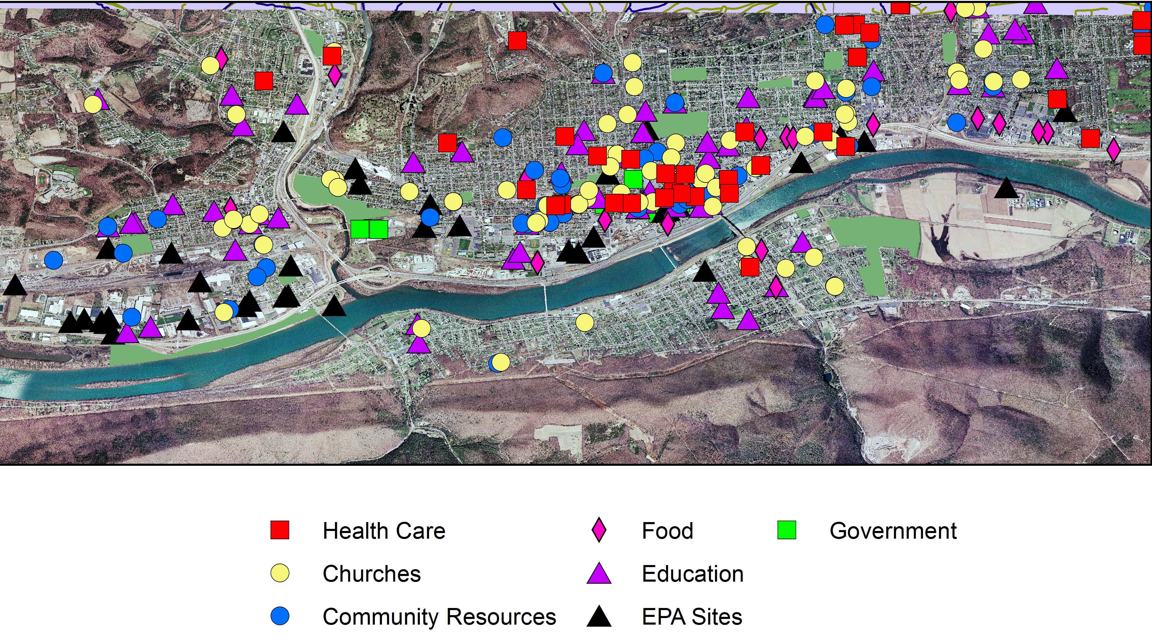
Data was collected on different Community Asset Classes (Churches, Healthcare providers, Food store, schools etc.). This information ranged from street address, contact information and a classification of what services each asset provided. These assets were then combined and mapped to give an idea of the spacial distribution of these assets.


Williamsport Community Assets

This project also serves as a template for future community asset data collection projects as the eventual goal is to expand this information to cover the Greater Central Susquehanna Valley. These proposed databases will serve as the foundation of a larger data project incorporating a ‘Community Platform’ that the university is contracting for from The Urban Institute and anascent regional ‘2-1-1’ social services phone line project.