Categories
Bucknell/Local Interest Environment GIS in Engineering GIS in Environmental Studies GIS Jobs, Internships, Scholarships & Grad Programs Slideshow

GIS in research (and the classroom): modeling sea level rise inundation

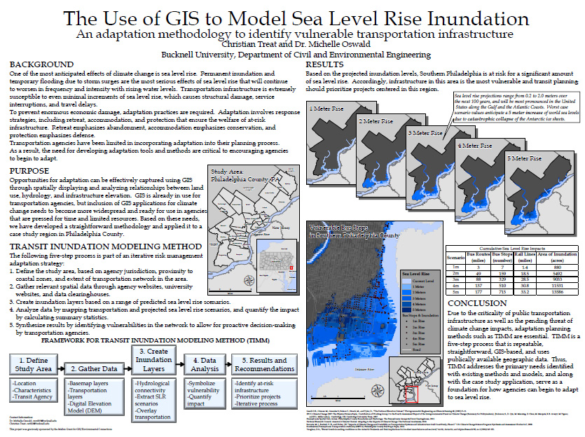
During Summer 2012, Prof. Michelle Oswald (Civil Engineering) and student Christian Treat ’13 (Animal Behavior) used GIS to model seal level rise inundation and identify vulnerable transportation infrastructure in the Philadelphia metropolitian area. Christian’s stipend for this summer research project was paid for out of Bucknell’s GIS student assistant fund (funded in part by the Mellon grant we got a few years ago… stay tuned for details on summer 2013 paid research opportunities).

Over the course of the 2012-13 academic year, Christian has continued developing this research project as an independent study and is listed as a co-author in an upcoming publication in the Journal of Public Transportation. At some point this spring I’ll post an interview with Christian discussing his work on this project – but for now, you can check out the poster he presented at last November’s ‘GIS & Spatial Thinking‘ conference.


¨Christian Treat ’13 (Animal Behavior)/Prof. Michelle Oswald (Civil Engineering) (Bucknell), ‘Using GIS to Model Seal Level Rise Inundation’

SLR_Treat

Categories
Bucknell/Local Interest GIS Jobs, Internships, Scholarships & Grad Programs Slideshow

Job & internships opportunities with ESRI

Check out these internships & job opportunities from ESRI. It’s a fantastic company to work for and could set you up for a very successful career in GIS work:

1. ESRI summer internship program:

Our Internship Program gives you a chance to work alongside Esri staff throughout the company.

  • Full-time, paid positions (up to 12 weeks)
  • Approximately 80 interns, primarily in Redlands but also in a few regional offices
  • Check your major to see where you would fit best
  • Apply now! The deadline is March 15, but positions are filled as qualified candidates are identified.
  • Have questions? We have answers.


2. ESRI User Conference student assistantship program:

Are you proud to call yourself a geogeek? Students selected for our Student Assistantship Program spend a full week at the Esri International User Conference in beautiful San Diego. In exchange for helping out during the conference, students attend sessions and network with others who share their passion for GIS. The application deadline is March 29. Students must be available to work Saturday, July 6, through Friday, July 12.

Read about Amelia’s experience as a student assistant at last year’s conference.

3. Full-time, permanent positions with ESRI:

Seniors: Ready for a New Campus? Graduating this semester? Congrats! Make the transition from your college campus to the Esri campus, where you’ll find a number of opportunities for new grads throughout the company. Learn where you might fit at Esri and then search current openings.

Check out our Life at Esri video.

There are still plenty of opportunities to meet our staff at campus events across the US this spring. Check our  interactive map for the schedule.

Categories
Environment GIS in Environmental Studies GIS in Geography GIS in Social Science GIS Jobs, Internships, Scholarships & Grad Programs Slideshow

Another summer 2013 GIS student research opportunity

Here’s info on another GIS student research opportunity for summer 2013. This one is hosted by Georgia State University. It’s part of the same NSF-funded ‘Research Experiences for Undergraduates (REU) program as the California State Long Beach program we posted about a few weeks ago.  The Geogria State program focuses on addressing social/environmental disparities through community geography and provides a stipend, housing and expenses. Deadline to apply is Friday, March 1st – so move fast!  More info from the announcement below.

Georgia State University will be hosting   This summer at Georgia State University in Atlanta, we are pleased to host the second year of our “Research Experiences for Undergraduates (REU) Site: Addressing Social and Environmental Disparities through Community Geography and Geographic Information Systems”.  The project is funded by the National Science Foundation.  The program runs June 10th – July 25th 2013.   The flier and application form are attached.

Research Interests: Working with faculty mentors in one of three research tracks, selectedundergraduates will engage in community-based research and fieldwork to quantitatively and qualitatively examine neighborhood change, property markets, social geographies, air and soil quality, urban green spaces, and neighborhood visioning in partnership with neighborhood residents and community groups in Atlanta, Georgia.

Compensation: Each REU student will receive a competitive funding package, including: a $3000 stipend, up to $250 in travel support to/from Atlanta, up to $750 for conference presentations, free room and most meals at GSU, and 3 required texts.

Application Process: Applications are due Friday, March 1st @ 5 PM EST.  Complete application instructions and the application form can be found at http://csaw.gsu.edu/nsf-reu/application-instructions/

To Learn More:  Visit http://csaw.gsu.edu/nsf-reu/

Any questions can be directed to the Dr. Timothy Hawthorne (PI) at thawthorne@gsu.edu or Dr. Katherine Hankins (Co-PI) at khankins@gsu.edu


Categories
Bucknell/Local Interest Digital Humanities General GIS GIS Jobs, Internships, Scholarships & Grad Programs Map Apps Slideshow

2 new job openings in GIS/digital scholarship at Bucknell

Bucknell has created 2 new job positions – GIS/Web Application Specialist and Digital Scholarship Coordinator – to support digital scholarship initiatives on campus. Click here to apply. The new hires will be part of the ITEC group within the Library and IT Division and will join a team of instructional technology specialists who focus on integrating GIS, digital media and other technologies across the curriculum at Bucknell.

Our ideal candidate for the GIS/Web Application Specialist position will have strong tech skills in GIS and web development combined with an interest in visualization and data graphics in general. As the first person to fill this role, the GIS/Web Application Specialist will have an opportunity to set the tone for what digital scholarship projects will look like at Bucknell. We are looking for someone who is creative, innovative and thrives on learning new tools & technologies. In addition to GIS and application development, the GIS/Web Application Specialist will have an opportunity to delve into a wide range of other types of visualizations – including timelines, networks, interactive graphs/charts, etc. – to create highly-interactive sites that showcase faculty & student research and can serve as teaching/scholarship tools. 

We have a wide range of exciting teaching and research projects already underway and we’re looking for these new hires to help showcase those efforts and take digital scholarship to a new level at Bucknell. I’ve been here for 3 and a half years and can tell you that Bucknell is an amazing place to work. The atmosphere is both collegial and collaborative. The faculty have a deep commitment to engaging students in learning, both in the classroom and through faculty-led and independent student research projects. In the last 4 years, Bucknell has created five new positions (GIS Specialist, Video Specialist, Instructional Technology Specialist, GIS/Web Application Specialist and Digital Scholarship Coordinator) to support this type of work on campus. That alone speaks volumes about the high level of support we have from the university administration and Library & IT leadership for doing innovative work.

If you are interested in either of these jobs or know of someone who might be, please check out the job descriptions. Feel free to contact me if you have any questions. Click here to apply.


Categories
Bucknell/Local Interest GIS in Geography GIS in History GIS in Humanities GIS Jobs, Internships, Scholarships & Grad Programs Slideshow

Summer 2013 GIS student research opportunities in Connecticut, California and Hawaii

Yes, we’re in the middle of a deep freeze, but it’s not too early to start thinking about summer 2013. Here are two opportunities for undergraduate students to do GIS research and field work. Both programs provide a stipend, housing and expenses. Deadlines are approaching fast so get moving if you want to apply for these!

(1) GIS Approach to Water Level Change – Keck Geology Consortium. Application deadline February 1, 2013. 

This project funds three students on a GIS project analyzing water levels, island area, and plant species richness for a study site in the Great Lakes. The students then continue with the project independently into the fall semester and present their work at the Keck Geology Consortium Undergraduate Research Symposium in the spring.

What: Investigation of spatiotemporal changes in island shorelines due to water-level changes using the mapping and analytical tools of a geographic information system (GIS). Study area is The Massasauga Provincial Park archipelago (Georgian Bay, Lake Huron, Ontario)

When: July 10 – August 7

Where: Wesleyan University. The project consists mainly of spatial analyses using ArcGIS but will also include training in field data collection.

(2) NSF REU – Geospatial Research and Mapping (GRAM) program. Application deadline March 1st, 2013

Geography and Archaeology undergraduates, as well as others interested in the study of landscapes, may be interested in our summer 2013 field program on geospatial research and mapping (GRAM) that will take place at both California State University Long Beach and at the famous* Kualoa Ranch in the picturesque Ka’a’awa valley on the north shore of O’ahu.

This field research program is a joint effort between faculty in the Department of Geography and Anthropology at CSULB and is focused on the use of cutting edge geospatial techniques (e.g., satellite and aerial imagery, the use of UAVs, geographic information systems, spectral analyses, topography generation, landscape analyses, and near surface remote sensing).   The research being undertaken by GRAM includes the study of prehistoric landscapes as well as contemporary resources and environments.

Our website (http://www.csulb.edu/colleges/cla/departments/geography/nsf-reu/) describes the overall program and include the research of last year’s students, the application form and additional program information. This is the second year of our 3 year project funded by the National Science Foundation (NSF) under their Research Experience for Undergraduates (REU) program.

This year’s GRAM project will take place June 2 to June 30 and include training in Long Beach and on Oahu. The NSF-REU program provides funding for student to cover travel, housing, tuition costs as well as a small stipend. Applications are competitive and open to undergraduates across the country.

The site of the field work is famously known as the location of the filming for Lost, Jurassic Park, among other TV shows and films.