
Categories
Bucknell/Local Interest Data Environment General GIS GIS in Computer Science GIS in Engineering GIS in Environmental Studies GIS in Geology Miller Run Restoration Project Slideshow

Keystone Edge story about the Flying Bison

The online journal, Keystone Edge, recently picked up the story of Nick Urban and the Flying Bison drone.  Published by Issue Media Group, the Keystone Edge

… tells the story of the new economy in Pennsylvania–a narrative of creative people and businesses, new development, cool places to live, and the best places to work and play. Each Thursday, the Web site and weekly online magazine presents original stories, video and photography to tell that story, from Pittsburgh to Philly.

An excerpt from the story is included below. Check out the full story here.

Innovation & Job News – Bucknell student’s remote-controlled plane captures imagery to aid creek restoration – THURSDAY, SEPTEMBER 01, 2011

Remote-controlled cars and airplanes were a hobby of Nick Urban’s when he was a boy. That interest remained as he pursued a computer science degree atBucknell University, where he spent this summer building a remote-controlled plane that’s being used to map the landscape around a creek that runs through Bucknell’s campus and into the Susquehanna River. The plane, dubbed the “Flying Bison,” was built of foam, includes Geographic Information System technology and can navigate predetermined paths on autopilot. Digital still and video cameras were attached to the plane so it could capture images of the Miller Run Creek as it flew around the waterway.


Categories
Digital Humanities General GIS GIS in History Slideshow

Using G.I.S. to Visualize Historical Landscapes

Guest post by Michael Grasso, Environmental Studes 13′

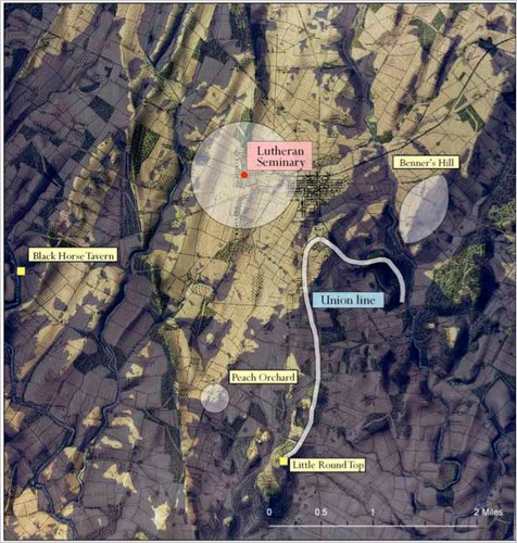
Geographic Information Systems can be used recreate a landscape that no longer exists. Historians can use this technology to help explain confusing, or even previously unexplainable, events that took place in the past. For example, General Robert E. Lee issued a series of orders (Pickett’s Charge) that directly caused the Confederates to lose the battle of Gettysburg and inevitably the Civil War. If anyone stood today where General Lee stood that fateful day they would be able to clearly see the fortified, superior Union force waiting for the charge – and wonder why Gen. Lee made the decision that he did. However, the landscape has dramatically changed in the 150 years since the Civil War.  Using historical maps and other documentation, geographers and historian were able to re-create the landscape that General Lee saw and to determine that – from his position 150 years ago -one could not see the eastern end of the battle field where Union forces were amassing.

This is a link to an article explaining how G.I.S. was used to answer questions be recreating historical landscapes such as the Battle of Gettysburg, the 1930s dust bowl, and the Salem Witchcraft Trials.