Categories
Bucknell/Local Interest Digital Humanities General GIS GIS in History Slideshow

Bucknell HGIS presentation at Yale

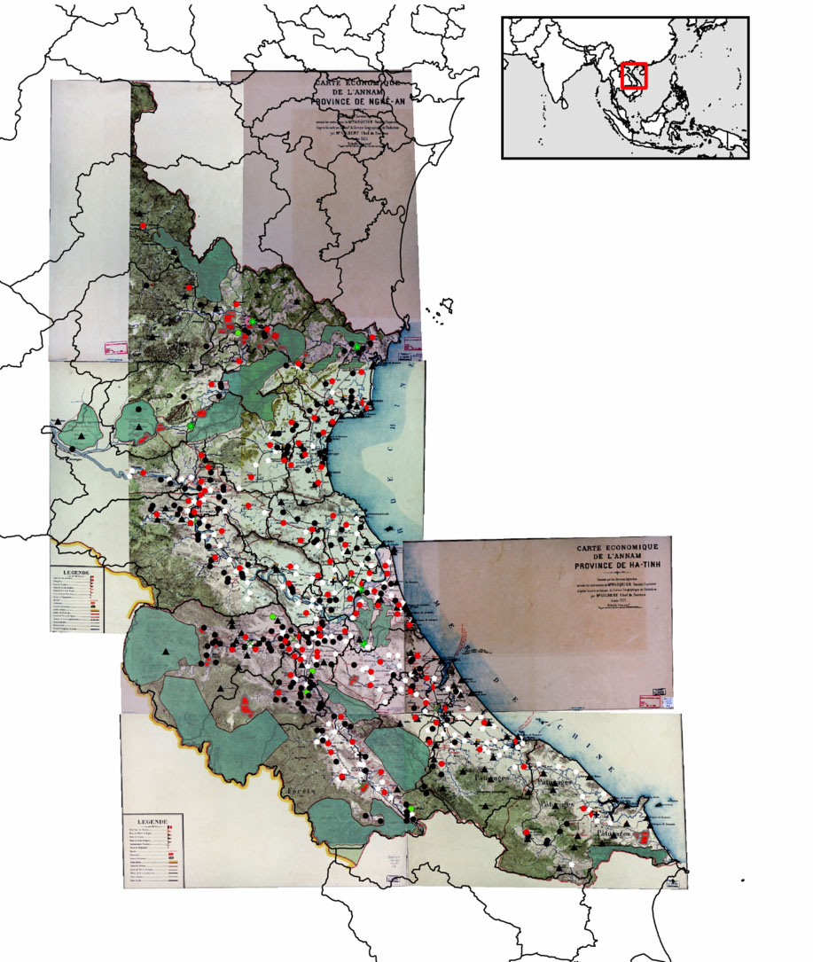
Over the last two and a half years, Bucknell History professor David Del Testa has been working – on his own and in collaboration with me and the GIS Student Assistants – on integrating GIS into his research on historical protest events in Vietnam.  Last October, Prof. Del Testa presented preliminary results from this work at UC Berkeley’s Center for Southeast Asia Studies. Click here to see a video of his presentation and to check out his H-GIS (historical GIS) blog Places, Spaces, Peoples, History.

On Wednesday, February 8th, Prof. Del Testa will be travelling to New Haven, CT to deliver another presentation of his work in progress. The presentation, called ‘Re-Evaluating Vietnam’s Nghe-Tinh Soviets (1930-31) using a Historical GIS,’ will be hosted by the Yale University Council for Southeast Asian Studies and is open to the public (in case you happen to be in the neighborhood… the talk will be held in Room 203, Luce Hall, 34 Hillhouse Avenue).

Here’s a link to the presentation announcement, along with an abstract:

“Reevaluating the Nghe-Tinh Soviets of 1930-1931 using a Historical GIS: Refining Some Preliminary Observations”
David Del Testa, Department of History, Bucknell University

The Nghe-Tinh Soviets of 1930-1931, a rebellion against colonial authority in north-central and central colonial Vietnam, has received extensive analysis by a variety of commentators and scholars, both Vietnamese and not. Most scholars, Vietnam and internationally, settled on some view of immiseration combined with the presence of pro-communist organizers as the motive forces for the rebellion, but a few have favored questions of political dissatisfaction and local empowerment as underlying motivations for revolt. Until recently, examining the rebellion on a gross scale in order to test either theory has proven difficult, with a surfeit of information but no easy way to process it in order to underwrite large-scale analyses. Del Testa is using a historical GIS (geographical information system) analysis, which blends statistics with digitized maps, in order to display correlations between factors, such as wealth, religion, and so on of those who rebelled in order to reexamine the Nghe-Tinh Soviets movement on a grand scale. His presentation will illustrate some initial findings as well as the techniques used.


Categories
Bucknell/Local Interest Digital Humanities Environment General GIS GIS in Computer Science GIS in Environmental Studies GIS in Geography GIS in Geology GIS in Public Health GIS in Sociology Slideshow

From the Yale Daily News… “Map on, Maples!”

The Yale Daily News has a great article about the role that the GIS Specialist, Stace Maples, plays on campus. Maples, a fellow ESRI T3G Institute alum from summer 2010, works with faculty and students on integrating GIS into teaching and research at Yale and…

… he is in high demand. Working in the three-person Map Department, a department within the Yale University Library, he trains students and faculty in the use of the arcane computer program. He helps professors in areas from history to public health, in such projects as diverse as mapping correspondence networks and placing photographic collections in a geological context. He is adamant that geographical data is relevant to all academic endeavors.

“Everything is somewhere, and that somewhere matters,” Maples declared.

Although I take issue with the reporter’s use of the word ‘arcane’ to describe GIS software, I’ll second Stace’s assessment that location matters (or, as the Geospatial Revolution team at Penn State put it, “the location of anything is becoming everything“).  In a statement that is sure to resonate with faculty, Peter Bol, the director of the Center for Geographic Analysis at Harvard University, is quoted in the article as saying that:

 “If you want to publish competitive research today, you have to have GIS.”

That might be a bit of an overstatement (for the moment, at least), but there’s no doubt that incorporating GIS and spatial analysis is increasingly becoming an expectation in academic research, much in the same way as it has become part of the fabric of our everyday lives.  Dana Tomlin – who is… a visiting faculty member in the Yale School of Forestry, co-director of the Cartographic Modeling Laboratory at the University of Pennsylvania, a GIS Hall of Fame-r, the creator of map algebra, and, incidentally, the grad school professor who got me hooked on GIS (thanks, Dana!), sums it up this way:

“With the advent of web mapping services like Google Earth and Bing, the ability to sense geographical position in real time via the Global Positioning System (GPS), and the opportunity to place this sort of magic quite literally into the hands of anyone with a smart phone, there is no question that the world at large is already well beyond the point of no return in terms of making routine use of geographical data in digital form.”

GIS has existed as a computing technology since the 1960’s, but until the mid to late 1990’s it was largely the domain of highly-trained specialists working from high-powered servers. GIS software and web-based map apps have become increasingly faster, more powerful and more user-friendly over the last 20 years. If those trends continue, and if we do our jobs well, Stace and I might very well work ourselves out of a job:

It is conceivable that GIS might one day become as ubiquitous within academia as Google Maps is within the broader population. If departments integrate GIS into their own teaching, the role that Maples and other specialists play is likely to diminish. Graduate students in fields employing GIS are expected to understand the program and its functionalities… Meanwhile, academics who only rarely use GIS might consult specialists if and when necessary, while remaining blissfully oblivious of the program’s nitty-gritty.

Today’s graduate students are tomorrow’s professors. And, if the trends hold true, at least a significant proportion of them will soon be using GIS technology to gain deeper insight into diverse fields of study for decades to come. So map on, Maples.

Click here to read the full story and learn more about how Yale faculty and students are using GIS to study history, archaeology, linguistics, environmental studies, forestry, public health and other topics.