Categories
Bucknell/Local Interest Data Environment Events/Calendar General GIS GIS in Computer Science GIS in Engineering GIS in Environmental Studies GIS in Geology Miller Run Restoration Project Slideshow

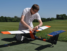
Physics Dept coffee talk on using the Flying Bison drone to collect aerial imagery

Come hear Nick Urban, Computer Science ’12, talk about designing, building and flying the remote-controlled Flying Bison drone. Nick will be presenting on Monday, 9/26 at noon (Olin 364) as part of the Physics department’s coffee talk series.  He’ll have the plane with him and will be showing some new video that will be captured by the drone in test flights he’s conducting this week.

Below are links to some previous blog posts about Nick’s Flying Bison and the Miller Run Restoration project that the drone collected data for.

1. Article by Julia Ferrante from Bucknell Communications office

2. A short video about the Miller Run Restoration project and the Flying Bison

3. An overview of the Miller Run Restoration project, including the role of the Flying Bison in collecting high resolution aerial imagery.

4. Some background on the spring 2011 competition that Nick flew the Flying Bison

By Janine Glathar

Janine Glathar joined the Digital Pedagogy & Scholarship team in 2009 to fill the newly-created role of GIS Specialist at Bucknell. She has worked in the field of geospatial technologies for more than 15 years as research specialist, technical analyst and software trainer. Prior to joining L&IT at Bucknell, Janine spent seven years doing applied GIS research in Philadelphia’s non-profit social services sector as the GIS Senior Analyst for Philadelphia Safe & Sound and the Greater Philadelphia Urban Affairs Coalition. Before transitioning to the social services research world, Janine worked for the GIS software company ESRI as a trainer and education/non-profit coordinator. She earned a B.A. in European History and Russian Language/Literature at the University of Pennsylvania. If you ask Janine where she’s from, she’ll tell you she’s a Navy brat and will probably offer to show you a map of all of the various places she’s lived over the years.

Areas of expertise:
ArcGIS, Digital Pedagogy, Digital Scholarship, GIS, Google Earth, Spatial Thinking