The NY Times has an interactive map graphic on the crisis in Libya. The series of maps traces the development of the rebellion and unrest from February 16th to present. The basemap data shown in the NYT interactive map graphic was provided by LeadDog Consulting. Given the unrest in Libya, LeadDog has been updating the street maps daily as they receive updated information. Click here for a detailed street map of Tripoli and here for a detailed street map of Benghazi.
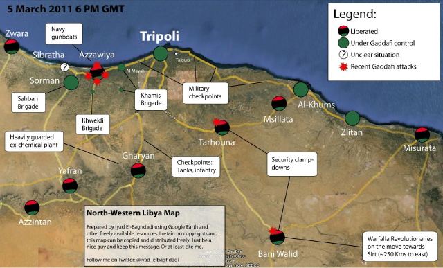
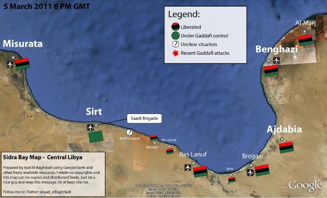
On the same topic, the NY Times 6th floor blog has a post about what may or may not be the Libyan opposition’s new website – which features news, announcements, video and a ‘Map of the Revolution.’ From the 6th Floor blog post:
Libya’s opposition seems to have surfaced online. NTCLibya.org was registered as a domain on March 6 for the Libyan Interim Transitional National Council. Among the tabs across the top of the site’s English-language home page are some you rarely see: Allegiances, Map of Revolution. A WhoIs search turned up Identity Protect as the administrator. This is a British company that manages domains while concealing the identity of the actual owner. So there has been a fair amount of Twitter chatter (#libya, #feb17) about whether the thing is legit. The council’s Twitter handle is @LibyanTNC. There hasn’t been a Twitter post for hours, and before that there were many to the effect of “hold on, i’m having trouble getting the site up.” And the site is indeed slow and only semifunctional. Which rather suggests it’s the real deal. The domain is registered until 2013. A little pessimistic?
‘Map of the Revolution’ – East Coast of Libya:
‘Map of the Revolution’ -West Coast of Libya: