Categories
Bucknell/Local Interest General GIS GIS in Film Studies Slideshow Videos

Mapping wheel-chair access at Bucknell

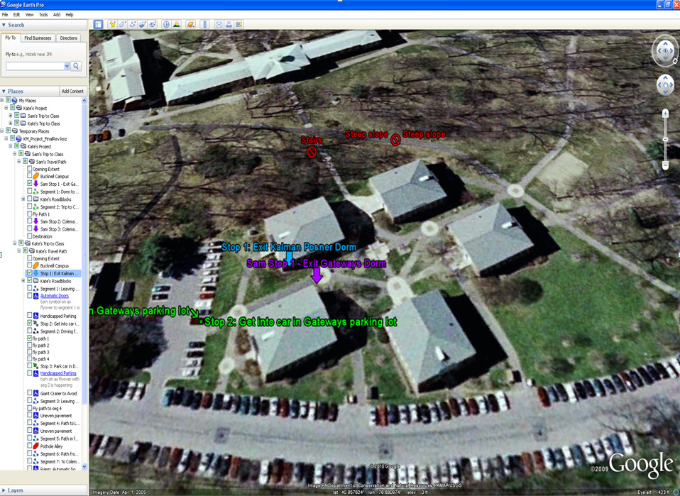
In spring 2010, Bucknell student Kate Matelan, ’10  worked with film professor Eric Faden to produce a documentary film focused on her experiences as a disabled student on campus.  To illustrate the differences between navigating the Bucknell campus in a wheelchair vs. on foot, Kate and I developed a GoogleEarth project with placemarks and travel paths to mark and annotate both her route and an able-bodied student’s route to a class held in Coleman 221.

In the film a 4-panel split screen (aka ’24’ style) approach was used to simultaneously present a GoogleEarth fly-over of each student’s travel path synced to video footage of the students describing the course of their daily trip to Coleman 221. See video excerpt and screenshot from GoogleEarth project below. I’ll make the KML file available as soon as I can figure how to to do that on WordPress.


Video Platform Video Management Video Solutions Video Player

Note: video footage was shot using several cameras including the GoPro Hero and Kodak Zi8. Editing was done in Final Cut Pro.

By Janine Glathar

Janine Glathar joined the Digital Pedagogy & Scholarship team in 2009 to fill the newly-created role of GIS Specialist at Bucknell. She has worked in the field of geospatial technologies for more than 15 years as research specialist, technical analyst and software trainer. Prior to joining L&IT at Bucknell, Janine spent seven years doing applied GIS research in Philadelphia’s non-profit social services sector as the GIS Senior Analyst for Philadelphia Safe & Sound and the Greater Philadelphia Urban Affairs Coalition. Before transitioning to the social services research world, Janine worked for the GIS software company ESRI as a trainer and education/non-profit coordinator. She earned a B.A. in European History and Russian Language/Literature at the University of Pennsylvania. If you ask Janine where she’s from, she’ll tell you she’s a Navy brat and will probably offer to show you a map of all of the various places she’s lived over the years.

Areas of expertise:
ArcGIS, Digital Pedagogy, Digital Scholarship, GIS, Google Earth, Spatial Thinking