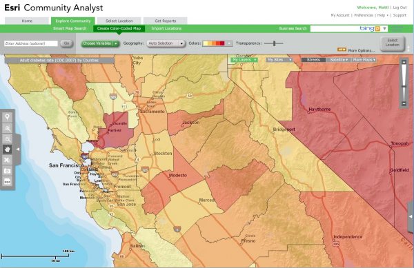
ESRI just added Business Analyst and Community Analyst to Bucknell’s site license. What that means for you is that you will soon have access to several thousand ‘ready-to-map’ data variables – all within ArcMap. You’ll also be able to use tools from the Business Analyst extension to do site selection, customer profiling, market penetration and other types of business analysis. But really, the exciting part here is the GIANT JACKPOT OF DATA. Check out the lists below to get an idea of the types of variables that you will be able to add to ArcMap with just the click of a mouse.
I’m working on getting these datasets pushed out to the labs and faculty computers as soon as possible. Stay tuned for more details.
Business Analyst Datasets:
Demographic Data
Current-year updates and five-year projections of Esri’s Updated Demographics use more than 1,600 variables about employee population, population by occupation/industry, disposable income, and consumer expenditures all at the United States, state, county, ZIP Code, census tract, block group, core-based statistical area, and designated market area geography levels.
Segmentation Data
Esri’s Tapestry Segmentation classifies U.S. neighborhoods into 65 segments based on their socioeconomic and demographic compositions. The market segmentation data is available at the census tract level and above.
Consumer Spending
Annually updated data details which products and services consumers buy. Approximately 90 variables in 15 categories such as apparel, food, and financial are included.
Business Data
A national database of approximately 12 million U.S. businesses from Infogroup to identify customers and competitors, business data is arranged by business name, industry description or SIC/North American Industry Classification System, sales, employees, and location.
Major Shopping Centers
The national database from the Directory of Major Malls, Inc., lists detailed information for more than 4,200 major shopping centers, malls, and lifestyle/specialty centers in the United States. Major shopping centers’ variables include center name, gross leasable area, type of center, total retail sales, distance to the nearest competing center, name of and distance to the nearest major city, and total number of stores.
Street Data
Tele Atlas’ high-quality, nationwide street and geocoding databases provide routing attributes and attractive map displays as a single street database source. Business Analyst Desktop includes Esri’s geocoder that integrates an address-based approach with more than 54 million residential and commercial U.S. structure addresses from the Tele Atlas Address Points database. This database maps street addresses to a physical location, so each address is a fixed point and not an interpolation from an address range.
Community Analyst Datasets:
| Bing Facility and Business Search |
| Infogroup Facility and Business Search |
| Mapping of Crime Data |
| Behavior and Preferences Reports |
| Electronics and Internet Market Potential |
| Financial Investments Market Potential |
| Health and Beauty Market Potential |
| Pets and Products Market Potential |
| Restaurant Market Potential |
| Retail Market Potential |
| Sports and Leisure Market Potential |
| Demographic Reports |
| 1990–2000 Comparison Profile |
| Age 50+ Profile |
| Age by Income Profile |
| Age by Sex by Race Profile |
| Age by Sex Profile |
| American Community Survey (ACS) Housing Summary |
| American Community Survey (ACS) Population Summary |
| Census 2010 Geography Profile |
| Census 2000 Detailed Race Profile |
| Census 2000 Summary Profile |
| Community Profile |
| Demographic and Income Comparison Profile |
| Demographic and Income Profile |
| Detailed Age Profile |
| Detailed Income Profile |
| Demographic Reports (continued) |
| Disposable Income Profile |
| Executive Summary |
| Graphic Profile |
| Housing Profile |
| Net Worth Profile |
| Quarterly Demographic Profile |
| Neighborhood Type Reports |
| Dominant TapestryTM |
| Tapestry Segmentation Area Profile |
| Spending Reports |
| Automotive Aftermarket Expenditures |
| Financial Expenditures |
| House and Home Expenditures |
| Household Budget Expenditures |
| Medical Expenditures |
| Recreation Expenditures |
| Retail Goods and Services Expenditures |
| Economic Activity Reports |
| Business Locator |
| Business Summary |
| Major Shopping Center Locator |
| Major Shopping Center Map |
| Retail MarketPlace Profile |
| Maps and Aerial Imagery |
| Site Details Map |
| Site Map |
| Site Map with Satellite Imagery |
| Traffic Maps and Reports |
| Traffic Count Profile |
| Traffic Count Profile Map |
| Color-Coded Maps and Smart Map Search |
| AGS CrimeRisk Data |
| Behavior and Preferences Data |
| Consumer Spending Data |
| Demographic Data |
| Economic Activity/Business Data |
| Neighborhood Type/Tapestry Data |
| Public Data (USDA, EPA, CDC, and more) |