The maps below were produced by the Women & Marriage group for Prof. Nikki Taylor’s ”Global Feminism & Religion” class. The group explored differences in marriage laws, norms and customs around the world and created maps in Google Earth to visualize countries according to four separate variables of interest: average age of marriage (men); average age of marriage (women); legal age of marriage (men); and legal age of marriage (women). In examining the map data they found that the legal age of marriage for each country seems to set the standard for the actual ages at which men and women marry. For example, in the United States, the legal age of marriage for men and women is the same (18 years old) for both genders – and the difference in the average age of marriage for men (28 years old) and women (26 years old) is very small. By contrast, in Niger the legal age of marriage for men is 18 – but for women it is only 15. The difference in the average age of marriage for men (25 years old) and women (17 years old) is fairly large and could be explained in part by the difference in the legal age of marriage for each gender.
Map 1 – Average Age of Marriage for Men:
Legend

Google Earth Map
Map 2 – Average Age of Marriage for Women:
Legend 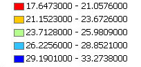 Google Earth Map
Map 3 – Legal Age of Marriage for Men:
Legend

Google Earth Map
Map 4 – Legal Age of Marriage for Women:
Legend  Google Earth Map